Karaganda: underwater drones study dams in a deep-sea way
Karaganda scientists will be able to find out the level of deterioration of dams. Underwater drones help them in this. With the help of an unmanned vehicle, it will be possible to make the most accurate measurements that will help avoid the breakthrough of dams.
As a result of a dam break in the village of Kokpekty, Karaganda region of the Republic of Kazakhstan, more than 50 houses were flooded in 2014. The damage amounted to almost 1.5 billion tenge. The main reason was called the deterioration of the reservoir.
To prevent such a situation, scientists of the Department of “Marshading and Geodesy” Map named after Abylkas Saginov undertook to examine dams and reservoirs using digital laser equipment.
Considering that most of the dams in the Karaganda region were built in the 50-60 years of the last century, the scientific activity of the department began to develop in the direction of marine geodesy, a new methodology was developed for determining the geometric parameters of both the bulk structures themselves and the reservoir.
— The main purpose of scientific research is to conduct multifactorial studies of water facilities with an assessment of safety and substantiation of the reliability of bulk facilities for timely identification of problems and adverse processes, ensuring improvement of operating modes of facilities, assessing the level of safety and risk of accidents, studying the impact of economic activities and infrastructures of water facilities and hydraulic structures on the environment, developing measures to neutralization of negative factors, — reported in the map.
This year, with grant funding, young scientists of the department are implementing a project to monitor the condition of critical hydraulic infrastructure facilities in Kazakhstan using unmanned aerial vehicles and remote sensing of the Earth.
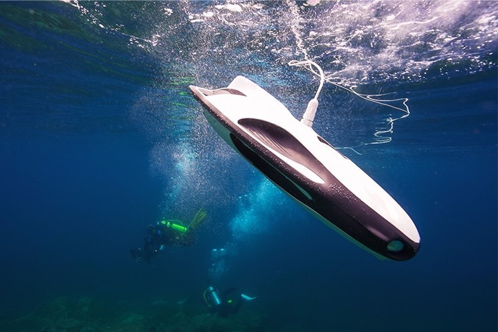
For these purposes, scientists use a unique underwater drone “PowerRay Explorer”, which promises a revolution in the field of marine geodesy.
The drone model is specially designed for high-precision measurements at great depths, where traditional methods of working with geodetic instruments are impossible. This project is important not only for geodesy, but also for ecology, as it minimizes the impact on the marine environment.
The underwater drone makes it possible to automate the processes of mapping the seabed, as well as surveying complex and hard-to-reach areas under water. It is equipped with sensors that allow you to accurately measure the depths, determine the relief and even track changes in the structure of the seabed over time.
At the moment, scientists are upgrading the underwater drone for more convenient operation.
— Now our colleagues are developing a module for positioning underwater so that our underwater drone has a coordinate reference underwater. That is, this technology is also being implemented now. I think we will have it in the near future. That is, it will be an upgrade of this drone. At the moment, in order to fix some damaged area, we visually saw it, we determined its profile, and in order for me to map it, I need to lift the drone at this point and fix it already on the surface of the water. Because the positioning systems that we are currently actively using, GNSS systems do not work underwater, they receive satellite signal distortion. And you have to do such unnecessary actions, as it were,” says young scientist Dmitry Ozhigin.
Kazinform